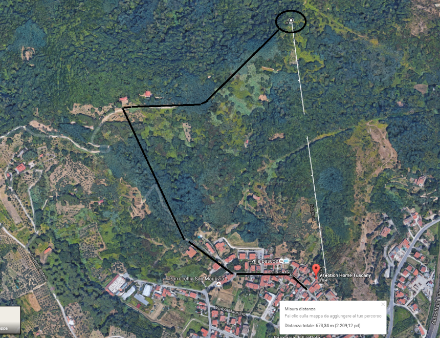
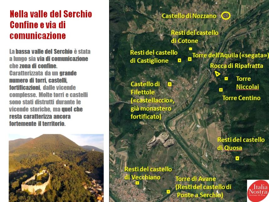
Castles and ruines in the nearby / Castelli e rovine nei dintorni
Click on the map below to get more information / cliccate sulla mappa sottostante per ulteriori dettagli
This is the closest medieval tower in the nearby / Questa è la torre medioevale più vicina


EN
Pisa Hills Wine Trail Medieval hamlets, traditional tastes and unique landscapes
The Wine Trail of the Pisa Hills is an itinerary through the Tuscan countryside, which highlights many small towns that boast great traditions. In the immediate vicinity of Pisa, the trail winds through farmlands, hills and valleys. It is a highly accessible itinerary and can be explored with environmentally-friendly alternatives to cars, like bicycles. From gently rolling plains to hills rich in centuries-old woodlands, chestnut forests and the typical Tuscan vegetation that changes at different times of the year, this unique landscape has impressive views. The trail is dotted with small towns and villages, some very ancient, where in addition to the vestiges of the past, the visitor can savour the peaceful rhythm of farm life and splendid views of the countryside.
The nearby sea offers a varied diet of local culinary specialties and fine wines. The Wine Trail of the Pisa Hills is an ideal itinerary to practise sports in contact with nature, like hiking, mountain biking or horseback riding, combined with the experience of wine tasting and the enjoyment of delicious meals. Along the trail, you can visits historic monuments and priceless artworks. It is a pleasant itinerary, with a mild climate in the winter, where the visitor can choose to stay at one of the many tourist farms along the way.
Tourist itineraries
From San Miniato towards Palaia, La Rotta, Peccioli - This itinerary starts from San Miniato, a town whose glorious past can still be seen in the many vestiges left intact. Following the directions for Marzana, you'll arrive at Marzana castle, an imposing edifice in the silence of the hilly landscape. Then take a road that winds through the hills covered with vineyards and olive groves and go to the church of San Giovanni Battista di Corazzano, where the road branches in three directions. Continue toward La Serra, but take a brief stop in Balconevisi to view the splendid scenery.
After leaving La Serra, visit Bucciano, an ancient village on top of a hill, reached along a road lined with centuries-old cypress trees and marked by a stone wash pit that was used for centuries by the local farmwives.
A little farther on is Palaia, first settled by the Etruscans. Here, without entering the town through its main gate, turn right to visit the church of San Martino, evidence of the passage from the Romanesque style to Gothic. Proceeding along this road, go as far as La Rotta, passing by San Gervasio, which has an ancient castle from the year 700 A.D. and where it is also interesting to visit the “Museum of Rural Civilization”. Here again, a deviation is advisable, for a visit to the characteristic villages of Forcoli and Villa Saletta. Now go to Montelopia to visit its castle, then Fabbrica di Peccioli and Montecchio, with its Romanesque church. Finally, go to Peccioli, a town on top of a lovely hills surrounded by vineyards, where the long domination of Pisa has left interesting architectural evidence, such as the Church of Verano and the various ruins of military constructions. The grape tradition here is so deeply rooted that the town is scattered with wine cellars, all of which claim to produce the best wine in the area.
From Palaia and proceed toward Montefoscoli. On the right, you'll encounter more ancient wash pits - “Fonchioni” - and an ancient altar, called “Figuretta”. From here, an unpaved road leads to the “Temple of Minerva Medica”, an original neoclassical construction built in 1823 and immersed in a forest. When you reach Montefoscoli, visit the Permanent Exhibition of Farm Civilization, and go on to visit the Astronomical Observatory at Libbiano. Reach Peccioli, after passing Ghizzano, where the little church just inside the town houses a number of ancient wood statues.
IT
LE COLLINE DI FILETTOLE
CAI 00 “Sentiero di Oltre Serchio ” (percorso segnato – vedi descrizione sulla carta tematica della Provincia di Pisa – “Monte Pisano”)
N°1 “Da FILETTOLE agli ULIVI DI PADULE”
La bella passeggiata ha inizio dal centro di Filettole e sale lungo il sovrastante versante collinare, dalla Via del Castello. Si apre alla vista un incantevole paesaggio naturale solcato dalla valle del Rio del Bucine, in buona parte sistemato a terrazzamenti ed oliveti. Sulla destra si elevano le torri del compendio storico del “Castellaccio”, retaggio architettonico dell’antico Monastero di Santa Viviana, in cui venne stipulata la pace tra Pisa e Lucca nel 1158. Proseguendo, si giunge fino al bivio per la Farneta, verso la direzione del Cancellino, dove il disegno delle sistemazioni agrarie lascia posto alla vegetazione tipica della macchia mediterranea d’entro terra. Il sentiero si apre tra arbusti di mirto, corbezzoli e fillirea, tra elicrisi e cisti, ai quali si alternano esemplari di roverella; sulla sinistra lo sguardo volge alla valle del Serchio e, più avanti, attraverso la valletta di Radicata, si può protrarre fino ai Monti di San Giuliano Terme ed alla “Rocca della Verruca” di Calci.
Comincia poi la discesa che porta alla Strada di Pietra a Padule, di fronte alla Bonifica del Lago di Massaciuccoli.
N° 2 “Da FILETTOLE alle “TRE VALLATE lucchesi”
Grado di difficoltà: FACILE
Tempo: 3 h
Percorso: TRATTO n° a-b-c-e-f-b
Partenza: Centro di Filettole, Via di Castello
=> Loc. “Farneta” => direzione verso “Il Cancellino” (OVEST)
=> “La Madonnina”
=> Loc. “Casa Nuova”
=> Loc. “Alla Pila”
Arrivo: bivio “La Farneta”
Ritorno: direzione Via del Castello => Centro di Filettole
Si percorre la via collinare che da Filettole conduce al “Cancellino”, giungendo fino alla “Madonnina”. Oltrepassata questa immaginetta, si apre sulla destra un sentiero stretto, in leggera salita, che attraversa la vegetazione spontanea arbustiva e porta ad un percorso principale pressoché pianeggiante, avanzante fino al promontorio lucchese delle “Tre Vallate”. Fanno da cornice i corbezzoli ed i biancospini, le fioriture stagionali di ginestre, eriche e cisti, alternate a querce e lecci. Da un ambiente aperto e soleggiato si passa ad uno più ombreggiato ed umido, con grandi coperture di felci e castagni. Proseguendo verso nord, il sentiero attraversa una pista del metanodotto, da cui si scorge, verso est, l’antica “Torre Segata” , mentre sulla sinistra si stagliano il Lago di Massaciuccoli e le pinete, gli abitati di Viareggio e Torre del Lago. Il sentiero prosegue in discesa, nella fitta macchia di castagni ed olmi, fino a condurre alla località “Casa Nuova” . Si completa, in un tragitto ad anello chiuso, al bivio della “Farneta”, per riportare all’abitato di Filettole.
N° 3 “Da FILETTOLE alla “TORRE SEGATA”
Grado di difficoltà: FACILE – SCONNESSO TRATTO FINALE
Tempo: 2 h
Percorso: TRATTO n° a-b-g
Partenza: Centro di Filettole, Via di Castello
=> Loc. “Farneta” => direz. verso “Torre Segata” (EST)
=> Loc. “Le Muracce”
=> Loc. “Torre Segata”
Arrivo: Loc. “Castello di Cotone”
Ritorno: Via Provinciale Vecchianese (verso Filettole)
Si percorre nuovamente la Via del Castello che da Filettole conduce al “Cancellino e, giunti al bivio per la “Farneta”, si volge a destra, in direzione delle località “La Fioraia” e “Le Muracce”. Il sentiero diviene pianeggiante e contornato da corbezzoli, cisti, ginestre ed eriche; apre lo sguardo verso la vallata orientale del Serchio e l’abitato di Filettole, facendo scorgere “Il Castellaccio” e la”Pieve di S.Maurizio”. Prosegue al rudere dell’antica “Torre dell’Aquila”, detta anche “Torre Segata”, per la sola metà della struttura muraria che la compone. Secondo la tradizione tramandata, la sua parziale demolizione sarebbe derivata dalla volontà dei pisani di non condividere la torre stessa con i lucchesi, essendo questa suddivisa dalla linea di confine dei due contadi.